

SHOALS Airborne Lidar Hydrography from Optech |
|||
 |
|||
|
Fast, Accurate and Cost-Effective where Acoustic Surveying is Most Limited
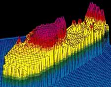
SHOALS also has a unique capability: it maps shallow waters, shoreline and topography (ground elevations) simultaneously, integrating land and water measurements in the same data set.
The SHOALS system combines a powerful, probing laser radar (lidar) and high-speed electronics on an airborne platform. Operating at altitudes of 200-400 metres, with laser spot spacing variable from 2x2 to 5x5 metres, SHOALS has a typical maximum depth penetration of 40-50 m in clear water, 20-40 m in coastal waters, and less than 20 m in more turbid inland waters.
Optech and Lidar Bathymetry
Optech has worked closely
with SHOALS system operators and data specialists.
The result of this long product commitment is the next-generation
SHOALS-1000, which Optech is now manufacturing.
Many of the SHOALS data and other images on this site are provided courtesy of JALBTCX. |
|||
Powerful Solutions for Instrumentation & Control Problems! SHOALS Airborne Lidar Hydrography from Optech |
|||
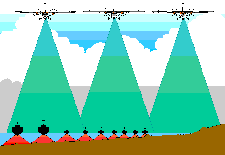 Optech's
SHOALS airborne lidar bathymeters are
now a well-proven tool, used for hundreds of surveys
in a wide range of applications. Based on the
same principle as sonar, but using light instead of
sound, SHOALS surveys clear water at
depths of 0-50 m, and land. Depth and position
measurements are accurate to IHO Order 1.
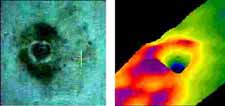 As well as surveying water depths from
the air, and thus avoiding the time and access problems
that bedevil other surveying methods, SHOALS
can identify underwater objects as small as 2x2x2 metres
resting on the ocean floor.
 Main
Customers
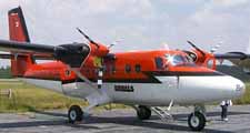 Optech
is the industry leader in lidar bathymetry, from building
the world's first commercial lidar hydrography system
in the early 1980s (LARSEN 500, still in operation),
to designing, developing and manufacturing four of the
six commercial systems in operation today. Optech's
lidar hydrography systems have been in operation since
the mid-1980s.


